The Atlantic hurricane season is a time of heightened alert, but it is the Eastern Pacific Ocean that is currently grabbing the attention of weather forecasters and coastal communities. What began as a tropical disturbance has now intensified, officially becoming Hurricane Gil. For those tracking the storm, the evolution of tropical storm gil hurrican has been a fast-moving and dynamic event. While this storm currently poses no direct threat to land, its powerful nature and swift development underscore the importance of staying informed and prepared throughout hurricane season.
This comprehensive article provides a detailed look at Hurricane Gil, its current status, and its forecasted path. We will break down what the latest weather models are predicting, explain what storm categories mean for those living in or near coastal zones, and offer essential preparation tips for staying safe during any severe weather event. From understanding “spaghetti models” to assembling a disaster kit, this guide is your go-to source for valuable, actionable information on this powerful storm.
Latest Updates on Hurricane Gil
As of the latest reports, the weather system has officially surpassed the tropical storm threshold and is now a hurricane. Here are the key details from the most recent advisories.
Current Status and Location
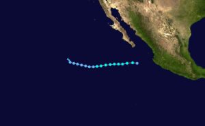
Hurricane Gil is located in the Eastern Pacific, a significant distance from any landmass. As of Saturday morning, August 2, 2025, the storm’s center was positioned well to the west-southwest of the southern Baja California peninsula. The storm is moving rapidly to the west-northwest at a speed of approximately 20 mph (31 km/h). This quick forward motion, combined with its current location over open water, means the storm’s primary threat is to marine vessels in the area. Maximum sustained winds have reached 75 mph (120 km/h), officially classifying it as a Category 1 hurricane on the Saffir-Simpson Hurricane Wind Scale.
Watches and Warnings in Effect
A key piece of good news for coastal residents is that there are currently no coastal watches or warnings in effect for Hurricane Gil. Forecasters are confident that the storm’s path will keep it over the open ocean for its entire lifecycle, and it is not expected to make landfall. However, this does not mean that coastal areas should be entirely complacent. Distant storms like Gil can still generate significant ocean swells and dangerous rip currents, making beach and boating conditions hazardous in affected regions. The public is advised to heed all local warnings regarding rip currents and marine conditions.
Understanding the Path: From Tropical Storm to Potential Hurricane
For many, the distinction between a tropical storm and a hurricane can be confusing. The process of a storm intensifying is a complex interplay of atmospheric conditions and ocean temperatures.
The Lifecycle of a Tropical Cyclone
Tropical cyclones, the generic name for these rotating weather systems, begin as tropical depressions. Once the maximum sustained winds reach 39 mph (63 km/h), the system is officially named and classified as a tropical storm. This is the stage where the storm receives its name, which for this system was Gil. The storm continues to pull energy from warm ocean waters, and if conditions are right, its wind speeds will increase further. When winds hit 74 mph (119 km/h), the storm is upgraded to a hurricane. This is a critical point of development, as the storm begins to take on the well-defined, organized structure—including the characteristic “eye”—that we associate with hurricanes. The current status of tropical storm gil hurrican shows that this system has successfully made that transition, evolving into a more powerful and dangerous weather system.
Spaghetti Models Explained
When you see a hurricane tracker on the news, you often see a cluster of different colored lines showing the storm’s projected path. These are known as “spaghetti models.”
- What they are: Each line on the map represents the forecast from a different computer model, run by various meteorological agencies and research institutions. No single model is always correct, but meteorologists can gain a better sense of a storm’s most likely path by observing where the majority of the lines cluster.
- How to interpret them: A tightly clustered group of lines indicates high confidence in a storm’s path. A widely scattered group suggests greater uncertainty. In the case of Hurricane Gil, the models are largely in agreement that the storm will continue on a west-northwest track, though there is some slight variance.
- The NHC Forecast: The National Hurricane Center (NHC) uses these models, along with expert analysis, to create its official forecast track. The latest NHC prediction for Hurricane Gil’s path is slightly to the south of some previous forecasts, but it maintains the expectation that the storm will remain far out to sea.
The Forecasted Path for Gil
The current forecast for Hurricane Gil predicts a relatively short lifespan at its current intensity. As the storm continues on its west-northwest track, it is expected to encounter cooler ocean temperatures and less favorable atmospheric conditions over the next 48 hours. This will cause the storm to weaken. Forecasters predict that Gil will likely be downgraded back to a tropical storm and eventually become a post-tropical cyclone or dissipate entirely within the next four to five days. This weakening process will prevent it from ever threatening land, but it reinforces the need for coastal communities to stay aware of the storm’s remnants and their potential for generating dangerous waves and currents.
Preparing for the Storm: Actionable Steps
Even when a storm like Hurricane Gil is not a direct threat, its existence should serve as a crucial reminder to review and update your hurricane preparedness plan. Being ready is the best way to ensure the safety of you and your family when a storm does pose a risk.
Here are some essential steps to take:
- Assemble a Disaster Kit: This should be a portable kit with enough supplies to last each family member for at least 72 hours.
- Non-perishable food and water.
- Flashlights with extra batteries.
- A battery-powered or hand-crank radio.
- First-aid supplies, including any necessary prescription medications.
- Copies of important documents (e.g., insurance policies, identification) in a waterproof bag.
- Create a Family Communication Plan: Identify an out-of-state contact person for family members to call, as long-distance lines may be more reliable during a local emergency. Designate a meeting place if you are separated.
- Secure Your Property: If you live in an area that could be affected by even a distant storm, take precautions.
- Bring in or secure any outdoor furniture, trash cans, or other items that could become airborne in strong winds.
- Trim dead or overhanging tree branches.
- Check your roof for any loose shingles.
- Stay Informed: Follow official sources like the National Hurricane Center (NHC) and local emergency management agencies. Do not rely on unverified social media posts for critical information.
Frequently Asked Questions (FAQ)
Q: What is the difference between a tropical storm and a hurricane?
A: A storm’s classification is based on its maximum sustained wind speed. A tropical storm has sustained winds between 39 and 73 mph. Once the winds reach 74 mph or higher, the storm is classified as a hurricane.
Q: How is a hurricane’s strength measured?
A: A hurricane’s wind speed is measured using the Saffir-Simpson Hurricane Wind Scale. This scale ranks storms from Category 1 (74-95 mph winds) to Category 5 (157 mph or higher). It’s important to remember that this scale only measures wind speed, and not other deadly hazards like storm surge, rainfall, and flooding.
Q: When will Tropical Storm Gil make landfall?
A: Based on all current forecasts, Hurricane Gil is not expected to make landfall. Its path will keep it over the open waters of the Eastern Pacific, and it is projected to weaken and dissipate before approaching any coastal communities.
Conclusion
The rapid intensification of the weather system from a tropical storm gil hurrican is a powerful reminder of nature’s unpredictable force. While Hurricane Gil poses no direct threat to land, it serves as an invaluable lesson in storm awareness and preparedness. The best defense against any tropical weather system is knowledge and a solid plan. By understanding the science behind the forecast, paying attention to official advisories, and taking proactive steps to prepare, you can ensure your safety and that of your community.
For the latest updates and to track the storm’s progress, we recommend you consistently monitor the official advisories from the National Hurricane Center and your local weather service. Stay safe and prepared.