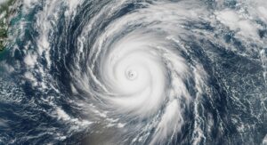
Hurricane Kiko, once a powerful Category 4 storm, is steadily weakening as it moves west-northwest across the Central Pacific. Forecasters track its projected path north of the Hawaiian Islands, expected to bring surging swells, rain, and gusty winds between Tuesday and Wednesday. Although Kiko’s core may stay offshore, its broad reach poses real threats, particularly from surf and flash floods.
As of Sunday, Kiko is a Category 3 hurricane, located roughly 635–715 miles east of Hilo, moving at 12–13 mph. Wind speeds have diminished from earlier peaks. Yet, its outer force extends far: hurricane-force winds spreading up to 35 miles from the center, and tropical-storm-force winds reaching 80 miles. These outer bands may deliver impactful weather even without a direct path over land.
Local authorities, including Governor Sylvia Luke, declared a statewide emergency to mobilize resources and warn residents. Emergency shelters are opening, and National Guard and disaster funding are being readied. Despite the storm’s gradual weakening, the government emphasizes vigilance—especially with seas expected to rise and rip currents threatening east-facing shores.
Kiko’s Track, Strength, and Forecast
Kiko navigated unusual intensification earlier this week, becoming a Category 4 hurricane powered by warm waters and low wind shear. Still, its course now steers it toward cooler and more hostile environments. Forecasts from AccuWeather and other agencies predict consistent weakening over the next few days, possibly reducing Kiko to a tropical storm by midweek.
Models concur that Kiko will pass north of Hawaii, keeping its center offshore. That said, uncertainty remains within the storm’s “cone of probability,” meaning eastern and northern islands could experience direct effects if the track shifts slightly southward. Meanwhile, large swells generated by Kiko are already expected to batter the Hawaiian coastline through Tuesday.
Local forecasters expect rainfall of 1–2 inches across most islands, with higher amounts—2–4 inches and occasional maxima up to 10 inches—on the windward and elevated terrains of the Big Island, Maui, and O‘ahu. Wind gusts may reach 40–60 mph along exposed areas, enhancing the risk of flash floods and erosion in vulnerable zones.
Immediate Impacts: Surf, Rip Currents, and Rain
Though Hawaii may avoid a direct strike, Kiko’s influence is far from harmless. Swells initiated by the storm are already underway, with warnings of life-threatening surf and dangerous rip currents—particularly on east-facing beaches where waves may surge between 10 to 15 feet.
Onshore, scattered showers and increased humidity are expected throughout Tuesday and Wednesday. The moisture plume spanning the islands intersects weaker trade winds, delivering cloudier skies and occasional downpours. While winds remain moderate, sudden gusts and heavy rainfall may affect low-lying and flash-prone areas.
A particular concern lies in the Big Island’s eastern slopes, where orographic lift could enhance rainfall, and in dry areas, where winds may elevate wildfire risk. Residents in these zones are encouraged to prepare accordingly and avoid high-risk outdoor areas during peak hazard periods.
Comparing Kiko to Past Pacific Hurricanes
| Storm | Peak Intensity | Track Relative to Hawaii | Primary Hazards |
|---|---|---|---|
| Kiko (2025) | Category 4 (peak), now Cat 3 | Predicted to pass north | High surf, rain, rip currents |
| Fico (1978) | Category 4 | Passed just south | Surf damage, coastal flooding |
| Kilo (2015) | Category 4 | Remained offshore | Rain, flooding |
| Typical Tropical Storm | Category 1–2 | Varied | Rain & wind damage |
Compared to past storms like Fico and Kilo, Kiko follows a familiar pattern: near-miss proximity still yields strong surf, rainfall, and disruption without landfall. Communities have experienced similar impacts previously when storms stayed offshore but closely aligned.
Preparedness and Recommendations
- Monitor updates: Stay informed via the National Hurricane Center, NOAA, and local advisories. Conditions may change rapidly, and forecast tracks can shift.
- Avoid beaches: East-facing shores may face hazardous surf and rip currents. Swimming or surfing is not advised until warnings lift.
- Secure outdoor items: Even weaker winds can become dangerous if debris flies. Anchor furniture, secure banisters, and be ready for gusts.
- Watch for rain-related hazards: If you live in low-lying or flash-flood prone areas, have an evacuation or action plan ready.
- Check on vulnerable neighbors: Assist seniors or those with mobility issues in preparing for shelter, especially in high-risk zones.
These steps can help reduce harm and strengthen community resilience in the face of Kiko’s evolving threat.
Outlook: What’s Next for Kiko?
By midweek, Kiko will likely have weakened to a tropical storm or dissipated below tropical strength. The most acute threats will shift from wind to water—surf, rain, and currents. Once the system clears, Hawaii can expect lingering swells and high humidity before a gradual return to normal trade-wind patterns.
Future risk depends on whether the storm’s center veers south into Hawaii’s “cone of uncertainty.” A southward shift would significantly increase rainfall and wind threat across islands. Emergency plans remain in effect through at least midweek, and communities should stay prepared until all signals clear.
Scientific monitoring and recovery planning now begin. The post-storm period will focus on coastal assessments, erosion impact studies, and community support, ensuring Hawaii is ready for future offshore storms—even those that don’t make direct landfall.