As the sun rises on Tuesday, August 19, 2025, Dare County is in the final stages of its mandatory evacuation. While the weather on Hatteras Island today may appear calm—with partly cloudy skies, a high of 28°C (82°F), and a light east wind of 19 mph—this serenity is a deceiving prelude to the dangerous conditions expected to arrive in the coming days. The latest weather forecast indicates that Wednesday will bring heavy thunderstorms and winds gusting up to 36 mph, while Thursday could see winds of 38 mph and light rain. These conditions are not directly from the hurricane’s eye, but rather from its extensive outer bands and the powerful ocean swells it is generating. The phased evacuation plan is crucial for a smooth and orderly departure, and officials are urging residents to complete their preparations and leave the island by the 8:00 a.m. deadline. This proactive measure is a key component of the region’s emergency response strategy, as it aims to clear the island of people before the only road in and out, NC Highway 12, becomes submerged and impassable.
The National Hurricane Center (NHC) continues to provide crucial updates on Hurricane Erin, which has been fluctuating in intensity over the past 48 hours. After reaching a peak as a ferocious Category 5 storm, it has since weakened slightly to a Category 4, but forecasters are quick to note that this is a temporary change. The storm is currently undergoing an “eyewall replacement cycle,” a natural process in which a new eyewall forms around the old one. During this time, the storm’s intensity can temporarily wane, but it is often followed by a period of re-strengthening. This is a critical piece of information for officials in Dare County, NC, as they must plan for the possibility of a stronger storm, even if the immediate forecast shows a slight weakening. The overall size of Hurricane Erin is also a major concern. The storm’s tropical-storm-force winds extend a staggering 200 nautical miles from its center, meaning its impacts are far-reaching and will affect the entire East Coast, regardless of its precise track.
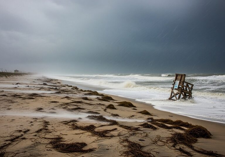
The hurricane erin path tracker shows the core of the storm is expected to pass roughly midway between Bermuda and the U.S. East Coast by the middle of the week. This track, while safer than a direct hit, is still close enough to generate life-threatening surf and rip currents from Florida all the way up to Atlantic Canada. The NOAA Hurricane Center and The Weather Channel are both emphasizing that the risk of coastal flooding and beach erosion is extremely high for the Outer Banks, as the storm’s powerful swells and sustained onshore winds will push a tremendous volume of water onto the barrier island. The forecast for Wednesday and Thursday shows significant rainfall and strong winds, which will combine with high tide cycles to create a perfect storm for ocean overwash. Sections of NC 12, particularly the most vulnerable parts of the road, are expected to be closed for several days, severing the connection to the mainland. For this reason, the hatteras mandatory evacuation is not just a suggestion; it is a critical safety measure to prevent people from becoming trapped.

Emergency Preparedness: Beyond the Checklist
While an emergency kit checklist is a good starting point, true preparedness involves a deeper understanding of the risks and a well-thought-out plan. It’s not just about having supplies; it’s about knowing what to do with them and when to act. For example, knowing your specific evacuation zone—in this case, Zone A for all of Hatteras Island—is paramount. The Dare County NC Emergency Management website has detailed maps and resources that allow residents and visitors to pinpoint their zone and understand the specific evacuation orders that apply to them. Furthermore, having a communication plan that includes a designated out-of-state contact is a simple but effective strategy. This is because local communication systems can become overwhelmed or fail during a storm, while long-distance calls and texts may still go through. Being aware of these small details can make a huge difference in a stressful situation. The mandatory evacuation order for Hatteras Island, which applies to both residents and visitors, is a testament to the community’s experience and the seriousness of the threat. Everyone on the island is now expected to be taking the necessary actions to secure their property and leave.
The “hurricane erin update” from the NHC also highlights the potential for strong winds, even if the core of the storm remains offshore. The Outer Banks, with its sparse tree cover and numerous structures, is particularly vulnerable to wind damage. Gusts from the outer bands of a major hurricane can be strong enough to cause power outages, down trees, and turn loose objects into dangerous projectiles. This is why securing all outdoor furniture, trash cans, and other items is a critical step in pre-storm preparation. It’s a simple action that can prevent significant property damage and injury. Officials are also warning about the potential for flash flooding from heavy rains, even in areas that are not typically prone to coastal flooding. This is a major concern for parts of the mainland of Dare County, which could see significant rainfall from the storm’s outer bands. The combination of coastal flooding and flash flooding creates a high-risk environment and makes travel extremely dangerous. The mandatory evacuation is a clear signal that the time to prepare is over and the time to act is now. The “hatteras island mandatory evacuation” is not a suggestion but a critical safety measure.
The table below provides a comparative look at the types of impacts expected on Hatteras Island as opposed to other regions affected by Hurricane Erin, such as Puerto Rico and Bermuda. This comparison helps to illustrate the diverse range of threats a large hurricane can pose and why a single storm can affect different areas in very different ways. The table includes information on wind, flooding, and travel disruptions, highlighting the primary risks for each location. For instance, while Bermuda may face a more direct wind threat, Hatteras Island’s biggest challenge is coastal flooding and ocean overwash due to its low elevation and vulnerable geography. This is a critical distinction that helps explain why officials in each location are issuing different types of warnings and advisories. The data helps us understand the multifaceted nature of hurricane preparedness.
| Location | Primary Threat (Hurricane Erin) | Expected Impact | Status and Action |
|---|---|---|---|
| Hatteras Island, NC | Coastal Flooding & Storm Surge | Significant ocean overwash and road closures on NC Highway 12. Severe beach erosion. | Mandatory evacuation for visitors and residents. County-wide swimming prohibition. |
| Bermuda | Wind & Rain | Direct hit from powerful winds and heavy rainfall. Power outages and structural damage possible. | Emergency preparations underway. Residents urged to shelter in place. |
| Puerto Rico | Rain & Landslides | Heavy rainfall from outer bands causing flash flooding and mudslides. Power outages. | Some shelters opened. Ports closed and reopened. FEMA assistance deployed. |
| New York, NY | Dangerous Rip Currents | High surf and powerful rip currents along beaches due to offshore swells from the hurricane. | Beach advisories and warnings issued. Swimming in open water is not recommended. |
Why this Storm is a “Monster”
The term “monster” has been used to describe Hurricane Erin by forecasters and the media alike, and it’s not simply because of its wind speed. While its Category 4 winds are indeed destructive, the true “monstrous” nature of this storm lies in its sheer size and the breadth of its impact. The hurricane’s wind field is so vast that it is generating powerful swells and a dangerous storm surge that will affect a massive portion of the East Coast, even without a direct landfall. The fact that the Outer Banks is facing a mandatory evacuation and a major coastal flood threat from a storm that is hundreds of miles away is a perfect example of this. This is a key difference from smaller, more compact storms, whose impacts are more localized. A large storm like this acts like a massive plunger in the ocean, pushing an immense amount of water ahead of it and creating hazards far beyond its core. This is why the coastal flood watch is in effect, and why the threat is so much more than just a gust of wind. The impacts of this storm are a powerful lesson in how the size of a hurricane can be just as important as its intensity.
For those in the Outer Banks, the term “hurricane” is not just about wind and rain; it is synonymous with ocean overwash and impassable roads. The very geography of the barrier island makes it uniquely vulnerable to the type of threat that Hurricane Erin presents. Its narrow, low-lying profile means that even a moderate storm surge can completely submerge sections of the island, cutting off communities and making escape impossible. This is a harsh reality that has been faced time and time again by the residents of the Outer Banks, and it is a major reason why emergency officials have adopted such a cautious and proactive approach to evacuations. The forecast of 15–20-foot waves offshore, with even higher waves at Diamond Shoals, is a dire warning that the protective dunes and fragile coastline are about to face a tremendous amount of stress. This is not just a passing thunderstorm; it is a major weather event with the potential to reshape the coastline and cause widespread damage. The today’s news is that a community is bracing for impact, and the world is watching.
The lessons from Hurricane Erin will undoubtedly shape future emergency management strategies. The rapid intensification of the storm, its temporary weakening, and its subsequent re-strengthening are a reminder of how dynamic and unpredictable these systems can be. This is why the scientific community, led by agencies like NOAA, is constantly working to improve its forecast models and data collection methods. The use of advanced satellite technology and hurricane hunter aircraft provides forecasters with the real-time data they need to make the most accurate predictions possible. But even with the best technology, there is still an element of uncertainty, and this is why preparedness is so critical. The path of Hurricane Erin 2025 is a powerful case study in the importance of heeding all official warnings and not underestimating the power of a major storm, even if its eye is not headed directly for you. This storm is a testament to the fact that it is not just the wind that is dangerous, but the water as well. The combination of storm surge, high tides, and high surf is what makes this storm so dangerous and why the mandatory evacuation is a necessary action to protect lives and property.
Full-stack developer at Scylla Technologies (USA), working remotely from Bangladesh. Adobe Certified Magento Developer.