In a remarkable geological event that has captured the attention of scientists worldwide, the Hayli Gubbi volcano in northeastern Ethiopia erupted on November 23, 2025, marking its first confirmed activity in approximately 12,000 years. The eruption sent massive ash plumes soaring to altitudes of 45,000 feet, drifting across the Red Sea and affecting air quality in multiple countries including Yemen, Oman, India, and Pakistan. This unprecedented event has raised significant questions about dormant volcanoes and the ongoing tectonic activity in East Africa’s volatile Afar region.
The Historic Eruption Event
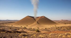
The explosive eruption began at approximately 8:30 a.m. local time on Sunday morning in Ethiopia’s remote Afar region. According to the Toulouse Volcanic Ash Advisory Center, which monitors volcanic activity for aviation safety, the initial blast generated an ash column that reached between 13 to 15 kilometers into the atmosphere. Satellite imagery captured by international monitoring agencies confirmed the eruption’s onset, with thermal signatures and sulfur dioxide emissions detected almost immediately.
Local residents described the eruption as a terrifying experience. Ahmed Abdela, a resident of the Afar region, told reporters that the explosion felt like a sudden bomb had been thrown, creating shock waves that reverberated through nearby communities. The sound was so powerful that it caused noticeable vibrations in areas around the town of Afdera, located near the volcanic site. For communities accustomed to the relatively predictable activity of the nearby Erta Ale volcano, this sudden awakening of Hayli Gubbi came as a complete surprise.
Immediate Impact on Local Communities
The eruption’s immediate effects were most severely felt in the village of Afdera and surrounding settlements. Thick layers of volcanic ash blanketed the area, covering homes, vegetation, and grazing lands. Mohammed Seid, a local administrator, reported that while no human casualties or livestock deaths occurred during the eruption itself, the economic implications for the community could be severe and long-lasting. The Afar region’s economy relies heavily on livestock herding, and the ashfall has significantly reduced access to clean grazing areas for animals.
Residents who had been traveling to the Danakil Desert, a popular tourist destination known for its otherworldly landscapes and extreme temperatures, found themselves stranded. Tour guides and visitors alike were forced to remain in ash-covered villages as the eruption continued for several hours. By Monday evening, the explosive activity had ceased according to advisory updates from the Volcanic Ash Advisory Center, but the aftermath continued to affect daily life in the region.
Understanding Hayli Gubbi Volcano
Geological Characteristics and Location
Hayli Gubbi is classified as a shield volcano, characterized by its broad, gently sloping profile formed by the accumulation of fluid lava flows. The volcano rises approximately 521 meters above sea level and features a symmetrical scoria cone with a crater measuring about 200 meters in width. Located in the southernmost position of the Erta Ale Range, Hayli Gubbi sits within one of the most geologically dynamic regions on Earth.
The volcano’s location in the Afar Depression places it at a unique triple junction where three tectonic plates meet and diverge. The Arabian Plate, the Nubian Plate, and the Somali Plate are actively pulling apart at a rate of approximately 0.4 to 0.6 inches per year. This tectonic activity creates conditions where hot rocks from the Earth’s mantle rise toward the surface, melting into magma and potentially feeding volcanic eruptions. The region represents an active continental rift zone where a new ocean basin may eventually form if the plates continue their current trajectory.
Historical Volcanic Record
According to the Smithsonian Institution’s Global Volcanism Program, Hayli Gubbi has no confirmed eruptions during the Holocene epoch, which began approximately 11,700 years ago at the end of the last Ice Age. This makes the November 2025 eruption extraordinarily significant from a geological standpoint. However, Dr. Juliet Biggs, an earth scientist at the University of Bristol in England, expressed skepticism that the volcano has truly remained dormant for such an extended period.
Satellite imagery analysis conducted prior to the eruption revealed subtle signs of activity that researchers had been monitoring. In July 2025, the nearby Erta Ale volcano experienced an ash eruption, and satellite data simultaneously detected ground movement indicating that magma from Erta Ale had intruded more than 18 miles below the surface, extending under Hayli Gubbi and beyond. Additional observations noted white puffy clouds at Hayli Gubbi’s summit and ground deformation showing the volcano had risen several centimeters, suggesting magma accumulation beneath the surface.
The Science Behind the Eruption
Volcanic Mechanisms and Magma Movement
The eruption of Hayli Gubbi presents an unusual case study for volcanologists. Shield volcanoes like Hayli Gubbi and Hawaii’s Mauna Loa typically produce effusive eruptions characterized by relatively gentle lava flows rather than explosive ash columns. The powerful explosive nature of this eruption, generating an umbrella-shaped ash cloud, is considered rare for this volcanic type and region. This unexpected behavior suggests that the magma composition or gas content may differ from typical shield volcano eruptions.
Professor Simon Carn from Michigan Technological University confirmed the eruption through satellite imagery and reported a major release of sulfur dioxide, a primary indicator of explosive volcanic activity. Sulfur dioxide is released when magma rises close to the surface and during active eruptions, making it a crucial monitoring parameter for volcanic hazards. The substantial SO2 emissions detected from Hayli Gubbi represent some of the largest recorded from any volcano in the Erta Ale range.
Arianna Soldati, a volcanologist at North Carolina State University, explained that the East African Rift System creates persistent conditions for magma generation. As the Earth’s crust pulls apart, it stretches and thins, allowing hot mantle rocks to rise and melt. This process can sustain volcanic activity indefinitely, meaning that volcanoes can erupt after millennia of dormancy as long as the tectonic conditions remain favorable for magma formation.
Scientific Response and Field Research
The eruption triggered an immediate scientific response from researchers studying the region’s volcanic systems. Dr. Derek Keir, an earth scientist at the University of Southampton in England, happened to be conducting fieldwork in Ethiopia when the eruption occurred. He quickly mobilized to collect ash samples from the fresh deposits on Monday, November 24. These samples will undergo detailed laboratory analysis to determine the magma’s chemical composition, crystallization history, and gas content, providing crucial insights into what triggered the eruption after such a long dormancy period.
The remote and inhospitable nature of the Afar region has historically limited comprehensive geological studies of its numerous volcanic features. The Danakil Depression, where Hayli Gubbi is located, ranks among the hottest and most inaccessible places on Earth, with temperatures regularly exceeding 100 degrees Fahrenheit and minimal rainfall. These extreme conditions, combined with occasional security concerns in the region, have resulted in incomplete volcanic records and limited understanding of many Afar volcanoes’ eruptive histories.
Regional Volcanic Context
The Erta Ale Volcanic Range
Hayli Gubbi is part of the Erta Ale volcanic range, a chain of volcanic features in the Afar Depression. The range’s namesake, Erta Ale, meaning “smoking mountain” in the local Afar language, represents Ethiopia’s most active volcano and has been erupting continuously since at least 1967. Erta Ale is famous for hosting one of the world’s few persistent lava lakes, which has existed since at least 1906, making it the longest-lived lava lake on record.
The volcanic activity in the Erta Ale range occurs within the broader context of the East African Rift System, an approximately 4,000-mile-long feature that initially formed during the Miocene epoch around 25 million years ago. The rift system created distinctive horst and graben topography, characterized by alternating raised and lowered blocks of crust, resulting in a landscape of deep valleys and highlands throughout Ethiopia and Kenya.
Recent volcanic activity in the region has been frequent. The Dalaffilla volcano within the range erupted in 2008, while various lava flows occurred in 2005, 2007, and between 2017 and 2020. In July 2025, just months before Hayli Gubbi’s eruption, Erta Ale itself experienced a significant ash eruption that may have been connected to the subsequent activity at Hayli Gubbi through subsurface magma movement.
Tectonic Setting and Future Implications
The Afar Triple Junction represents one of the most geologically significant locations on Earth. Here, three major tectonic plates meet and actively diverge, creating a natural laboratory for studying continental rifting and the birth of new ocean basins. The ongoing separation of these plates suggests that East Africa is gradually being pulled apart, and if current trends continue over millions of years, the Arabian Sea and the rift valley could merge to form a new ocean, effectively creating a separate island continent from eastern Africa.
According to the British Geological Survey, over 46 percent of Ethiopia’s population lives within 100 kilometers of a Holocene volcano, exposing nearly half the nation to potential volcanic hazards. This demographic reality, combined with the region’s frequent seismic activity, creates ongoing challenges for disaster preparedness and risk management. From late 2024 through early 2025, several earthquake swarms affected areas near the Fentale and Dofan volcanoes in Ethiopia’s Awash National Park, demonstrating the persistent tectonic unrest throughout the region.
Ash Cloud Dispersal and International Impact
Atmospheric Distribution
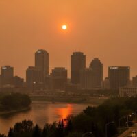
The volcanic ash cloud from Hayli Gubbi’s eruption demonstrated the far-reaching impacts of major volcanic events. Satellite tracking by multiple international agencies showed the ash dispersing in multiple directions based on atmospheric conditions at different altitudes. Lower-level ash drifted northwest over the Red Sea toward Djibouti and Yemen, while higher-altitude ash was carried rapidly eastward by the subtropical jet stream.
Professor Simon Carn confirmed that the ash cloud spread quickly over the Arabian Sea toward northwestern India and Pakistan, traveling at speeds between 100 to 120 kilometers per hour. The Volcanic Ash Advisory Center in Toulouse issued multiple advisories for aircraft operating in the region, as volcanic ash poses serious risks to aviation. Ash particles can damage jet engines, abrade aircraft surfaces, and reduce visibility, making accurate tracking and forecasting of ash clouds essential for flight safety.
The upper-level ash reached parts of Iran, northern India including Gujarat and Rajasthan, and extended toward China according to various monitoring reports. The widespread distribution of the ash cloud highlighted the global connectivity of atmospheric systems and how volcanic eruptions, even in remote locations, can have international implications.
Air Quality Monitoring and Response
Neighboring countries implemented immediate monitoring measures to assess potential air quality impacts from the volcanic emissions. The Environment Authority in Oman released statements confirming they were closely monitoring emissions resulting from the eruption to safeguard public health and air quality. The authority operates 68 monitoring stations distributed across Oman’s governorates, including eight stations in Dhofar and five in Al Wusta, providing continuous surveillance of pollutant concentrations around the clock.
As of the most recent updates, Omani authorities confirmed that no increases in pollutant concentrations had been recorded within their territory, and there were no indications that air quality had been affected by the volcanic emissions. Similarly, Yemen and other countries in the ash cloud’s path maintained heightened surveillance but reported no immediate air quality deterioration affecting populated areas.
Impact on Local Livelihoods and Economy
Effects on Pastoralist Communities
The Afar region’s economy depends heavily on pastoralism, with communities raising livestock including goats, sheep, camels, and cattle. The volcanic ashfall created immediate challenges for these livestock herders. The ash covering vegetation and grazing lands reduced food availability for animals, while contamination of water sources raised concerns about livestock health. Local administrator Mohammed Seid emphasized that while no livestock deaths were reported immediately after the eruption, the longer-term economic implications could be substantial.
Volcanic ash can have complex effects on agriculture and livestock management. In the short term, ash can contaminate water supplies, damage vegetation, and make grazing difficult. However, over longer periods, volcanic ash can enrich soils with minerals and nutrients, potentially improving agricultural productivity. The net effect depends on ash thickness, composition, and local environmental conditions. For the immediate future, Afar communities face the challenge of managing their herds with reduced grazing capacity while the landscape recovers from the ashfall.
Tourism Industry Disruption
The Danakil Depression has emerged as an increasingly popular destination for adventure tourists seeking to experience one of Earth’s most extreme environments. The region attracts visitors interested in seeing active lava lakes at Erta Ale, colorful sulfur formations, and otherworldly salt flats. The unexpected eruption disrupted tourism activities, stranding visitors and guides in ash-covered villages.
Tour operators who facilitate expeditions to Erta Ale and other Danakil attractions face uncertainty about when normal operations can resume. Safety concerns related to potential continued volcanic activity, combined with the practical challenges of operating in ash-affected areas, may temporarily reduce tourism revenues that provide important income for local communities. The longer-term impact on tourism remains unclear and will depend on whether Hayli Gubbi continues to show activity or returns to dormancy.
Volcano Monitoring and Early Warning Systems
Satellite-Based Surveillance
The detection and tracking of Hayli Gubbi’s eruption relied almost entirely on satellite-based monitoring systems. Multiple satellite platforms contributed to the rapid identification of the volcanic activity. Planet Labs satellites captured visual imagery of the eruption plume, while specialized sensors detected thermal anomalies and sulfur dioxide emissions. These space-based observations proved crucial given the volcano’s location in an area with minimal ground-based monitoring infrastructure.
The Toulouse Volcanic Ash Advisory Center, one of nine VAACs worldwide responsible for monitoring volcanic ash hazards to aviation, issued the first official advisory about the eruption. The center’s analysts detected the ash plume using data from geostationary weather satellites and polar-orbiting environmental satellites. This multi-sensor approach allowed rapid characterization of the eruption’s magnitude and ash dispersal patterns.
Challenges in Remote Monitoring
The Afar region’s extreme remoteness and harsh environmental conditions create significant challenges for establishing and maintaining ground-based volcano monitoring systems. Traditional monitoring approaches using seismometers to detect earthquakes associated with magma movement, GPS stations to measure ground deformation, and gas sensors to track volcanic emissions are difficult to deploy and maintain in such an inhospitable environment.
Professor Atalay Ayele, Head of the Seismology Department at the Institute of Geophysics, Space Science and Astronomy at Addis Ababa University, noted that the Danakil Depression remains one of the most geologically active zones in the region, where ongoing subsidence and tectonic shifts consistently create conditions for eruptions. Ethiopian scientists have been working to enhance monitoring capabilities, but resource constraints and access difficulties limit the density of monitoring networks compared to volcanic regions in more developed countries.
Historical Volcanic Activity in Ethiopia
Previous Major Eruptions
Ethiopia has experienced numerous significant volcanic eruptions in recent decades, though many occurred in remote areas with limited documentation. The Dabbahu volcano erupted in 2005, triggering hundreds of earthquakes and creating a 500-meter-long fissure. The eruption darkened skies throughout the region with thick ashfall and demonstrated the potential for major volcanic events in the Afar Depression.
Mount Kilimanjaro in neighboring Tanzania, Africa’s highest peak at 5,895 meters, last erupted approximately 360,000 years ago and is considered dormant. Mount Kenya, an extinct volcano that last erupted over 2 million years ago, will never erupt again. These varying states of volcanic activity across East Africa illustrate the diverse volcanic history of the region.
Future Volcanic Hazards
The recent awakening of Hayli Gubbi after such a long dormancy period raises important questions about other potentially active volcanoes in Ethiopia that may have incomplete eruptive records. Dr. Juliet Biggs suggested that Hayli Gubbi may have experienced undetected eruptions during the past 12,000 years, and the same could be true for other volcanoes in the region. The limited historical documentation and challenging research conditions mean that many Ethiopian volcanoes remain poorly understood regarding their true eruptive frequency and hazard potential.
Volcanic eruptions may become more frequent sights for Ethiopians in the future, considering the active tectonic processes occurring throughout East Africa. As the continental rift continues to widen and new magma pathways develop, previously dormant volcanic systems may reactivate. This geological reality underscores the importance of improving volcano monitoring infrastructure and developing comprehensive hazard assessment and emergency response plans for vulnerable communities.
Scientific Significance of the Eruption
Advancing Volcanic Understanding
The Hayli Gubbi eruption provides scientists with a rare opportunity to study the reactivation of a long-dormant volcanic system. The ash samples collected by Dr. Derek Keir and other researchers will undergo detailed petrological and geochemical analysis. By examining the crystallization patterns, mineral compositions, and volatile content of the erupted material, scientists can reconstruct the conditions under which the magma formed and ascended to the surface.
Comparing the characteristics of this eruption with the typical effusive activity of shield volcanoes may reveal important insights about what triggers explosive eruptions in volcanic systems that normally produce quiet lava flows. The answer likely lies in factors such as magma composition, volatile content, ascent rate, or interactions between rising magma and groundwater. Understanding these triggers could improve eruption forecasting for similar volcanic systems worldwide.
Implications for Rift Valley Volcanism
The eruption adds to the growing body of knowledge about volcanism in continental rift settings. The East African Rift System serves as an analog for ancient rift systems preserved in the geological record and provides insights into how continents break apart and new ocean basins form. The magmatic activity observed at Hayli Gubbi and throughout the Afar Depression represents an active example of the processes that have shaped Earth’s surface throughout geological history.
Research conducted in the Afar region contributes to understanding magma generation, storage, and transport in rift environments. The July 2025 detection of magma movement from Erta Ale extending beneath Hayli Gubbi demonstrated that volcanic systems in the region are interconnected through subsurface magma pathways. This connectivity means that activity at one volcano can influence neighboring volcanic systems, complicating hazard assessment and eruption forecasting efforts.
Community Resilience and Response
Local Knowledge and Adaptation
Communities in the Afar region have adapted to living in one of Earth’s most extreme environments, developing traditional knowledge and practices for coping with volcanic hazards, extreme heat, and water scarcity. The local Afar people, who have inhabited the region for generations, possess valuable knowledge about recognizing volcanic precursors and managing during eruptive episodes.
Following the eruption, community members worked together to assess damage, protect livestock, and support those most affected by the ashfall. The absence of casualties despite the eruption’s magnitude reflects both the low population density in the immediate vicinity and the resilience of Afar communities in responding to natural hazards. However, the economic challenges posed by reduced grazing capacity and potential long-term environmental changes will require sustained support and adaptation strategies.
Infrastructure and Emergency Preparedness
The eruption highlighted both strengths and gaps in Ethiopia’s volcano monitoring and emergency response systems. The rapid identification of the eruption through satellite monitoring demonstrated the value of remote sensing technologies, while the limited ground-based observations underscored the need for enhanced monitoring infrastructure in high-risk areas. Ethiopian authorities, including the Afar National Regional State government, are working to improve preparedness for future volcanic events.
The Afar region has been developing plans to establish a National Park of Volcanoes, which would formalize access to volcanic sites like Erta Ale while also supporting scientific research and monitoring activities. This initiative aims to balance tourism development, scientific investigation, and community needs while enhancing safety measures for residents and visitors alike. The recent eruption may accelerate these planning efforts by demonstrating the region’s active volcanic nature.
Global Context and Comparative Analysis
Similar Volcanic Awakenings Worldwide
Hayli Gubbi’s reactivation after millennia of dormancy is not unique in the global volcanic record. Several other volcanoes have awakened after extended quiet periods, sometimes with dramatic consequences. The 1991 eruption of Mount Pinatubo in the Philippines followed approximately 500 years of dormancy and became one of the 20th century’s largest eruptions. Chaiten volcano in Chile erupted unexpectedly in 2008 after approximately 9,000 years of inactivity.
These cases demonstrate that dormancy, even over thousands of years, does not equate to extinction in volcanic systems. As long as the underlying tectonic conditions favor magma generation, volcanoes can reactivate. This reality presents challenges for hazard assessment, as volcanoes without recent activity may receive less monitoring attention despite retaining eruption potential. The Hayli Gubbi eruption serves as a reminder to the global volcanological community about the importance of assessing hazards from historically inactive volcanoes.
Volcanic Risk in Developing Regions
The eruption underscores the particular challenges faced by developing countries in managing volcanic hazards. While technologically advanced nations like Japan, the United States, and Italy maintain extensive volcano monitoring networks with dense instrument arrays and dedicated research programs, countries with fewer resources must prioritize monitoring efforts strategically. Ethiopia, despite hosting numerous active and potentially active volcanoes, has limited resources for comprehensive monitoring compared to the scale of potential hazards.
International scientific collaboration has become increasingly important in addressing these monitoring gaps. Research partnerships between Ethiopian institutions like Addis Ababa University and international universities in England, the United States, and elsewhere bring additional expertise and resources to studying Ethiopian volcanism. These collaborations enhance local monitoring capabilities while advancing global understanding of rift-related volcanic processes.
Looking Forward: Ongoing Monitoring and Research
Continued Surveillance of Hayli Gubbi
Following the initial eruption, scientists continue monitoring Hayli Gubbi for signs of renewed activity or gradual return to dormancy. Satellite observations track any thermal anomalies, ground deformation, or gas emissions that might indicate magma movement beneath the volcano. The crucial question remains whether this eruption represents an isolated event or the beginning of a new phase of activity at Hayli Gubbi.
Historical patterns at other shield volcanoes suggest various possibilities. Some shield volcanoes produce single eruptive episodes followed by extended quiet periods, while others enter phases of recurring activity with eruptions occurring at intervals of months to years. The magma system’s behavior over the coming months and years will provide valuable information about Hayli Gubbi’s likely future activity patterns.
Advancing Monitoring Technologies
The eruption has renewed discussions about deploying enhanced monitoring infrastructure in the Afar region. Potential improvements include installing additional seismometers to better detect earthquakes associated with magma movement, deploying GPS stations to measure ground deformation, and establishing gas monitoring stations to track sulfur dioxide and other volcanic emissions. Satellite-based technologies continue evolving, with new sensors offering improved spatial resolution and more frequent observations.
Emerging technologies such as drone-based monitoring systems may prove particularly valuable for studying volcanoes in remote and inaccessible areas like the Danakil Depression. Drones equipped with thermal cameras, gas sensors, and high-resolution cameras can provide detailed observations of volcanic features without requiring researchers to venture into hazardous terrain. As these technologies become more affordable and capable, they may transform volcano monitoring in challenging environments worldwide.
Environmental and Climatic Considerations
Atmospheric Impacts of Volcanic Emissions
The substantial sulfur dioxide release from Hayli Gubbi’s eruption has implications beyond immediate air quality concerns. When sulfur dioxide reaches the stratosphere, it converts to sulfate aerosols that can remain aloft for months to years, reflecting incoming solar radiation and potentially causing temporary cooling of Earth’s surface temperatures. However, the magnitude of Hayli Gubbi’s eruption appears insufficient to produce significant global climatic effects, unlike massive eruptions such as the 1991 Pinatubo eruption that caused measurable global cooling.
Interestingly, some researchers advocating for geoengineering approaches to counter global warming have proposed deliberately injecting sulfur dioxide into the stratosphere to mimic the cooling effects of large volcanic eruptions. While controversial, these proposals highlight how volcanic eruptions provide natural experiments for understanding atmospheric processes and potential climate interventions. The Hayli Gubbi eruption offers scientists another data point for studying how volcanic emissions interact with atmospheric chemistry and climate systems.
Long-term Environmental Recovery
The environmental recovery of areas affected by volcanic ashfall typically proceeds through several stages. Initially, ash covers vegetation and can smother plants, while water sources become contaminated with suspended particles. However, volcanic ash contains minerals and nutrients that can enhance soil fertility over time. The specific composition of Hayli Gubbi’s ash, which laboratory analysis of collected samples will reveal, determines its effects on soil chemistry and plant growth.
In the Afar region’s arid environment, rainfall plays a crucial role in washing ash from vegetation and incorporating it into soils. The limited precipitation in the Danakil Depression means that ash may persist on surfaces longer than in wetter climates, potentially prolonging impacts on vegetation and grazing capacity. However, the ultimately enriching effects of volcanic ash on soils could benefit plant growth once the ash becomes incorporated into the soil profile.
Conclusion
The November 2025 eruption of Hayli Gubbi volcano represents a significant geological event that captured international attention and sparked important discussions about volcanic hazards, monitoring capabilities, and community resilience in one of Earth’s most extreme environments. After approximately 12,000 years of dormancy, the volcano’s sudden reactivation sent ash plumes to record heights and affected communities and air space across multiple countries. While no casualties occurred and the eruption has since ceased, the event highlighted both the power of natural forces and the ongoing challenges of living with volcanic hazards in developing regions.
The scientific community has gained valuable data from this eruption, with ash samples and satellite observations providing insights into the reactivation of long-dormant volcanic systems. The event underscores the interconnected nature of volcanoes in the Afar Depression and the broader East African Rift System, where tectonic forces continue reshaping the continent. For local communities dependent on livestock and tourism, the eruption presented immediate economic challenges while demonstrating their resilience and adaptability in the face of natural disasters.
Moving forward, the eruption serves as a reminder of the importance of comprehensive volcano monitoring, international scientific collaboration, and community preparedness for volcanic hazards. As satellite technologies advance and monitoring networks expand, scientists will be better positioned to detect precursory signals and provide early warnings for future eruptions. The lessons learned from Hayli Gubbi’s awakening will inform volcanic hazard management not only in Ethiopia but worldwide, contributing to safer coexistence with the powerful geological forces that continually shape our dynamic planet.